Great Circle Routes are fundamental to understanding how airplanes fly between two points. They explain why you can look out of an aircraft window and see Greenland when you fly between Paris and Vancouver when you were expecting to see the transatlantic ocean. They explain why Helsinki has become a popular connecting point for travellers flying between Europe and China. And they explain why Dubai has become a global airport hub.
Key Points About Great Circle Routes
- Great Circle Routes represent the shortest path between two points on the globe and are fundamental to airline network planning and flight paths.
- Two-dimensional map projections, like Mercator, distort our perception of distance and routing, making these flight paths appear unusual when they are, in fact, the most direct.
- Major global hub airports have leveraged their strategic positions on Great Circle Routes to facilitate efficient passenger and cargo flows between continents.
- Operational and regulatory factors, as well as aircraft range, can influence actual flight paths, but minimising distance typically reduces fuel use and travel time.
- The ongoing success of hubs like Helsinki, Dubai, and Vancouver highlights the continued importance of Great Circle Routes in global aviation strategy.
With the popularity of flight trackers these days it’s easy to track flights from all over the world. However, as with any map, these tools provide a two-dimensional representation of a spherical object. On a three-dimensional globe, however, what might have appeared to be a strange flight route on a flight tracker will in fact be entirely logical and close to the shortest possible distance as an aircraft flight path will be an arc between the origin and destination.
It comes down to understanding that the earth is not flat, as we often perceive it on two-dimensional maps, but is three-dimensional and spherical or, to be precise, spheroid.
What is the Mercator Projection?
Most often when we look at a two-dimensional map, it is using the Mercator projection which has become our standard way of representing the map of the world in two dimensions. On the Mercator projection, north is always north and south is always south, and countries are in the right place relative to each other and remain roughly the right shape but in order to take a sphere and make it into a rectangle, cartographers need to distort the map. In practice, this means that on the Mercator projection the further away from the equator a landmass is, the more its area appears bigger than it actually is.
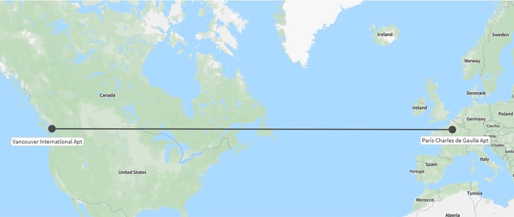
OAG’s Mapper tool is based on the Mercator projection. If we look to show a route as a straight line between, say Paris and Vancouver, which are about the same latitude, Mapper shows it like this.

Seeing this, it’s easy to think that a flight between the two cities would take us straight over the Atlantic Ocean.
Time to get the string out
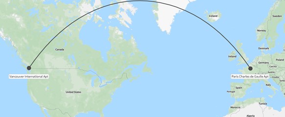
As someone who spends much of my time analysing air travel, I’ve worked with a globe on my desk for many years and can’t count the number of times I’ve pulled out a piece of string and stretched it across the surface of my globe. This is because aircraft don’t fly in a straight line according to the Mercator map, but instead tend to take the shortest flight route between two points. This is the Great Circle Route and is easy to see with a piece of string and a globe but when shown on a Mercator map the route looks more like this.

Now, it’s easy to see why this flight path has a birdseye view over Greenland.
Why are great circles the shortest flight path?
If you imagined splitting the Earth into two equal hemispheres starting from anywhere and cutting in any direction, the line you would cut along would be the circumference of the Earth. That is the Great Circle Route.
It’s because the Great Circle Route is the shortest distance between two points that airlines choose to fly along Great Circle Routes whenever they can. Of course, sometimes this isn’t possible; they may not be permitted through some airspace, or some aircraft might fly with requirements to be within a certain distance of land or a designated alternate airport, or fly so as to make the most of trade winds. These factors can distort the routing a bit, but in general, it makes sense to fly the shortest flight route possible. It’s usually fastest and therefore gets passengers where they want to go soonest, and uses less fuel because the plane is flying less distance.

Which airport Hubs have a natural geographic Advantage?
Many of the leading hub airports have been successful on the back of a natural geographic advantage they have based on Great Circle Routes. Although it’s not always easy to see on a standard map projection, these airports lie directly at the heart of one or more major air passenger traffic flows.

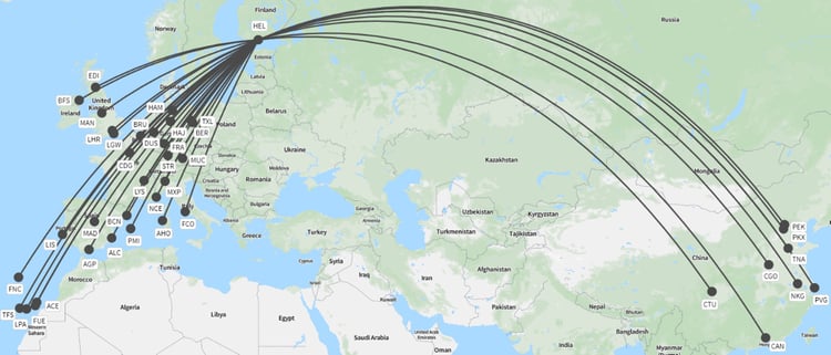
For years, people travelling between Europe and Asia, and specifically China, would have assumed that the best way to fly was via Hong Kong, the default gateway airport for China due to the role the United Kingdom played in the city-state’s history. Then Helsinki, which was thought of as being located on the far northern fringe of Europe realised that its position gave it a distinct advantage as a connecting point for travellers between Europe and China. The airport successfully developed a range of air services and a connecting product which enabled passengers to fly via Helsinki, shaving off a cumulative 1,600km on a flight from London Heathrow to Shanghai compared to flying via Hong Kong.
Dubai’s location effectively on the Great Circle Route between Europe and Australia has been a factor in its success too, and similarly Vancouver has benefitted from its location on a Great Circle Route between many North American cities and points in Asia.
It’s not just passenger flights that benefit from Great Circle Routes. Cities like Anchorage have been able to build cargo and freight distribution centres based on a location at the centre of a Great Circle Route between Asia and North America, and somewhere the airline can refuel and aircraft, handle flight crew changeovers and sort cargo.
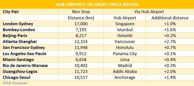
The table below lists some of the world’s hub airports that lie directly on, or close to, Great Circle Routes between some major city pairs. While the city pairs chosen have been selected to show off the geographic benefits of these hubs – in most cases a one-stop routing via the hub requires flying only 1% or 3% further than a non-stop flights - there are numerous other city pairs for which these hub airports can provide efficient one-stop air services.
While this list of hub airports is familiar, there are other airports which could take on this role, but haven’t yet. One example is Delhi in India which is well located to connect Europe-South East Asia traffic flows, as well as emerging China-Africa traffic flows.
The Earth is not flat
The aviation industry is always changing and adapting as new aircrafts come along, demand for air travel from certain markets waxes and wanes, and airlines thrive or falter. The need to continually adapt to changing market conditions has never been more apparent than through the global pandemic in 2020 and 2021 but some things do remain the same. The fact that the earth is not flat and Great Circle Routes are the basis of connecting different cities by air in the most efficient way will remain. Airline network strategy will continue to focus on connecting cities using Great Circle Routes to establish timetables that work for passengers and schedules that provide efficient operations.
Recommended:
The World's Shortest International Commercial Flights | Read Now


.jpg)


.png)


